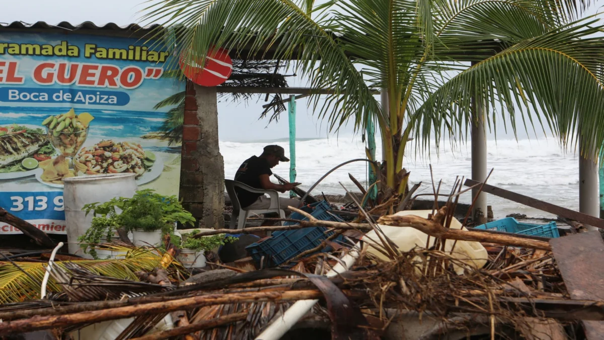
Hurricane Trudy brought heavy rain and strong winds to Mexico’s Pacific coast, with its center expected to stay near the coast through Sunday evening before moving south of the Baja California Peninsula.
The system has caused weather disruptions along the western coastline of Mexico. Authorities have been tracking Trudy’s progress as it maintains tropical storm-force conditions across parts of the region.
Key Facts
- Hurricane Trudy brought heavy rain and strong winds to Mexico’s Pacific coast.
- Trudy’s center was expected to remain near the Mexican coast through Sunday evening.
- Trudy was forecast to move south of the Baja California Peninsula.
What happens next?
Hurricane Trudy is expected to continue moving southwest, eventually shifting south of the Baja California Peninsula. The National Hurricane Center or local Mexican meteorological services may issue updated advisories depending on how fast the system weaken post-landfall. Tropical systems often lose structural integrity once they move over cooler ocean waters or higher terrain, though remnants can still generate localized impacts.
Coastal areas should remain on alert for surf conditions even after the center moves inland. Swells generated by the hurricane could affect beaches hundreds of miles away for several days. Emergency management officials will likely monitor river levels and drainage systems closely due to ongoing rainfall.
The Story
Who Is Affected?
Communities along Mexico’s Pacific coast from Sinaloa to Oaxaca are currently experiencing the effects of Hurricane Trudy. These regions often face seasonal threats during the late summer and early fall months, which correspond with peak hurricane activity in the eastern Pacific basin.
Fishing villages, small towns, and tourist destinations near the shoreline are particularly vulnerable to storm surge and flash flooding. Inland areas may also see rising water levels from saturated soil conditions combined with additional runoff. Power outages and transportation delays are commonplace when hurricanes make landfall in this region.
Government agencies such as the Secretaría de Seguridad y Protección Ciudadana have activated contingency plans in high-risk zones. Evacuation centers may open if conditions worsen unexpectedly.
How Did We Get Here?
Hurricane Trudy developed from a tropical wave that moved off the coast of Africa earlier this week. Atmospheric conditions favored rapid intensification, allowing the system to achieve hurricane status within 48 hours of formation. Warm sea surface temperatures and low wind shear contributed to its strength.
The storm initially targeted a glancing blow to the southern tip of Baja California Sur before turning northwestward toward mainland Mexico. Forecast models showed slight variations in track direction due to a mid-level trough influencing the steering flow.
Meteorologists rely heavily on satellite imagery and reconnaissance aircraft data to refine predictions about future paths. However, hurricane forecasting remains challenging beyond a seven-day window. Residents were advised to prepare emergency kits and secure property ahead of arrival.
What We Know — and What We Don’t
Verified by the source:
- Hurricane Truce brought heavy rain and strong winds to Mexico’s Pacific coast
- Trudy’s center was expected near the Mexican coast through Sunday evening
- The system was projected to move south of the Baja California Peninsula
Still unconfirmed:
- No specific dates or times provided beyond Sunday evening
- No reported damage totals or casualties included in the summary
- Exact location names or municipalities not specified beyond general geographic references
Hurricane Trudy underscores the ongoing risks posed by cyclonic storms along Mexico’s vast Pacific coastline. While most attention focuses on immediate safety concerns during landfall, longer-term consequences like infrastructure damage and economic disruption ripple outward long afterward.
See related updates in economy-markets and climate-environment coverage for broader implications affecting trade routes, agriculture, and energy production facilities.
Why It Matters
Hurricane Trudy serves as a reminder that despite advances in meteorology, hurricanes remain unpredictable forces capable of reshaping entire coastlines overnight. Understanding these phenomena helps communities build resilience and plan effectively for future seasons.
What To Watch
Local authorities may provide updated evacuation orders or shelter information. The storm’s path beyond Monday remains uncertain pending further model runs and satellite analysis.